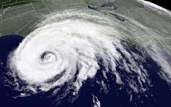
Ed. Note- The National Hurricane Center is offering free emailed text advisories of daily tropical forecasts for the North Atlantic and Pacific waters in English and Spanish that appear just as they do on the daily updated pages of the NHC site. This service offers the opportunity to receive hurricane advisory communication at a reasonable enough cost to be used by any mariner at home and/or at sea.
NEW! In their continuing program to improve the National Hurricane Center is offering more ways to communicate the latest hurricane announcements and updates as well as more accurate information. This year updates are available via Outlook RSS/XML feed, for PDAs and Smartphones, Podcast RSS/XML and GIS.
 Tropical Cyclone text products released by the NHC are available by email. This form allows you to subscribe and unsubscribe to any of the ten lists currently offered. The lists are arranged by region (Atlantic and E. Pacific), with the choice of receiving just the Public Advisories and any updates or position estimates, along with the Tropical Weather Outlook, just the Forecast/Advisories and any updates or position estimates, along with the Tropical Weather Outlook, or you can opt for the full suite of Tropical Cyclone advisories and the Tropical Weather Outlook.
Please Note:
This is an experimental service. Interruptions or duplications in
email deliveries while we develop the system are to be expected. Notices will
be sent if any extended interruptions are encountered.
IMPORTANT NOTICE:
We are currently accepting subscriptions to the advisory email lists. As we
continue developing the system we may have to limit the number
of new subscribers. If we do have to limit subscriptions a notice will be
posted to this page.
Disclaimer:
This server may not be available 24 hours a day, seven days a week.
Timely delivery of data and products from this server through the Internet
is not guaranteed. Please read the full Disclaimer
for more information.
Privacy:
You must provide a valid email address to subscribe to the service. The
server will reply to the address given to verify that the address is valid.
The email address is stored on the server only as long as you are subscribed
to the service. Please read the
NHC/TPC Privacy Statement
for full details on information gathered by the website.
The following products are available via email for the indicated areas
during the hurricane season (June 1 through November 30 for the Atlantic,
May 15 through November 30 for the Eastern Pacific):
- Forecast/Advisory (Atlantic and E Pacific)
- Public Advisory (Atlantic always, E Pacific only when land is threatened)
- Discussion (Atlantic and E Pacific)
- Probabilities (Atlantic only)
- Update (Atlantic and E Pacific...intermittent)
- Position Estimate (Atlantic and E Pacific...intermittent)
- Special Tropical Disturbance Statement (Atlantic and E Pacific...intermittent)
- Tropical Weather Outlook (Atlantic and E Pacific 4 times a day)*
*Only the early morning Tropical Weather Outlook is sent to all
lists. The Atlantic and East Pacific Outlook lists receive the
three remaining Outlooks for their respective regions.
Spanish translations of the Advisories and Outlooks courtesy of the
NWS San Juan Weather Forecast Office

Please note that there is overlap in the lists, so that, for example,
subscribing to both the FULL and PUBLIC ADVISORIES ONLY lists for the same
region will generate some duplicate email notices. It is suggested that
you subscribe to only one list per region and possibly the Outlook list
for that region if you wish to receive all of the Tropical Weather
Outlooks as well.
Important Note: the Atlantic Full list receives
a large amount of mail per day when one or more tropical cyclones
are active in the Atlantic. For most users the Atlantic (Public
Advisories and updates ONLY) list is probably adequate.
Please go to the link below for more information and to sign up for the advisories.
www.nhc.noaa.gov/signup.shtml
Glossary of NHC/TPC Terms
- Advisory:
- Official information issued by tropical cyclone warning centers
describing all tropical cyclone watches and
warnings in effect along with details concerning tropical cyclone
locations, intensity and movement, and precautions that should be
taken. Advisories are also issued to describe: (a)
tropical cyclones prior to issuance of watches and
warnings and (b) subtropical
cyclones.
- Best Track:
- A subjectively-smoothed representation of a
tropical cyclone's
location and intensity over its lifetime. The best track contains the
cyclone's latitude, longitude, maximum sustained surface winds, and
minimum sea-level pressure at 6-hourly intervals. Best track
positions and intensities, which are based on a post-storm assessment
of all available data, may differ from values contained in storm
advisories. They also generally will not reflect the erratic motion
implied by connecting individual
center fix positions.
- Center:
- Generally speaking, the vertical axis of a
tropical cyclone,
usually defined by the location of minimum wind or minimum pressure.
The cyclone center position can vary with altitude. In
advisory
products, refers to the center position at the surface.
- Center / Vortex Fix:
- The location of the center of a
tropical or
subtropical cyclone
obtained by
reconnaissance aircraft
penetration, satellite, radar, or synoptic data.
- Central North Pacific Basin:
- The region north of the Equator between 140W and the
International Dateline. The
Central Pacific Hurricane Center (CPHC) in
Honolulu, Hawaii is responsible for tracking
tropical cyclones in this
region.
- Cyclone:
- An atmospheric closed circulation rotating counter-clockwise in
the Northern Hemisphere and clockwise in the Southern
Hemisphere.
- Direct Hit:
- A close approach of a tropical cyclone
to a particular location.
For locations on the left-hand side of a tropical cyclone's track
(looking in the direction of motion), a direct hit occurs when the
cyclone passes to within a distance equal to the cyclone's
radius of
maximum wind. For locations on the right-hand side of the track, a
direct hit occurs when the cyclone passes to within a distance equal
to twice the radius of maximum wind. Compare
indirect hit, strike.
- Eastern North Pacific Basin:
- The portion of the North Pacific Ocean east of 140W. The National
Hurricane Center in Miami, Florida is responsible for tracking
tropical
cyclones in this region.
- Eye:
- The roughly circular area of comparatively light winds that
encompasses the center of a severe
tropical cyclone. The eye is
either completely or partially surrounded by the
eyewall cloud.
- Eyewall / Wall Cloud:
- An organized band or ring of cumulonimbus clouds that surround
the eye, or light-wind center of a tropical
cyclone. Eyewall and wall
cloud are used synonymously.
- Explosive Deepening:
- A decrease in the minimum sea-level pressure of a
tropical cyclone
of 2.5 mb/hr for at least 12 hours or 5 mb/hr for at least six
hours.
- Extratropical:
- A term used in advisories and tropical summaries to indicate that
a cyclone has lost its "tropical" characteristics. The term implies
both poleward displacement of the cyclone and the conversion of the
cyclone's primary energy source from the release of latent heat of
condensation to baroclinic (the temperature contrast between warm and
cold air masses) processes. It is important to note that cyclones can
become extratropical and still retain winds of
hurricane or
tropical storm force.
- Fujiwhara Effect:
- The tendency of two nearby tropical cyclones
to rotate cyclonically about each other.
- Gale Warning:
- A warning of 1-minute sustained surface winds in the range 34 kt
(39 mph or 63 km/hr) to 47 kt (54 mph or 87 km/hr) inclusive, either
predicted or occurring and not directly associated with
tropical cyclones.
- High Wind Warning:
- A high wind warning is defined as 1-minute average surface winds
of 35 kt (40 mph or 64 km/hr) or greater lasting for 1 hour or longer,
or winds gusting to 50 kt (58 mph or 93 km/hr) or greater regardless
of duration that are either expected or observed over
land.
- Hurricane / Typhoon:
- A tropical cyclone
in which the maximum sustained surface wind
(using the U.S. 1-minute average) is 64 kt (74 mph or 119 km/hr) or
more. The term hurricane is used for Northern Hemisphere tropical
cyclones east of the International Dateline to the Greenwich Meridian.
The term typhoon is used for Pacific tropical cyclones north of the
Equator west of the International Dateline.
- Hurricane Local Statement:
- A public release prepared by local
National Weather Service
offices in or near a threatened area giving specific details for its
county/parish warning area on (1) weather conditions, (2) evacuation
decisions made by local officials, and (3) other precautions necessary
to protect life and property.
- Hurricane Season:
- The portion of the year having a relatively high incidence of
hurricanes. The hurricane season in the Atlantic, Caribbean, and Gulf
of Mexico runs from June 1 to November 30. The hurricane season in the
Eastern Pacific basin
runs from May 15 to November 30. The hurricane
season in the Central Pacific basin
runs from June 1 to November 30.
- Hurricane Warning:
- A warning that sustained winds 64 kt (74 mph or 119 km/hr) or
higher associated with a
hurricane are expected in a specified coastal
area in 24 hours or less. A hurricane warning can remain in effect
when dangerously high water or a combination of dangerously high water
and exceptionally high waves continue, even though winds may be less
than hurricane force.
- Hurricane Watch:
- An announcement for specific coastal areas that
hurricane
conditions are possible within 36 hours.
- Indirect Hit:
- Generally refers to locations that do not experience a direct hit
from a tropical cyclone, but do experience
hurricane force winds
(either sustained or gusts) or tides of at least 4 feet above normal.
- Landfall:
- The intersection of the surface center of a
tropical cyclone with a coastline. Because the
strongest winds in a tropical cyclone are not located precisely at the
center, it is possible for a cyclone's strongest winds to be
experienced over land even if landfall does not occur. Similarly, it
is possible for a tropical cyclone to make landfall and have its
strongest winds remain over the water. Compare
direct hit,
indirect hit, and
strike.
- Major Hurricane:
- A hurricane that is classified as Category 3 or higher.
- Post-storm Report:
- A report issued by a local National Weather Service office
summarizing the impact of a tropical cyclone
on its forecast area.
These reports include information on observed winds, pressures, storm
surges, rainfall, tornadoes, damage and casualties.
- Preliminary Report:
- Now known as the "Tropical Cyclone Report". A report summarizing
the life history and effects of an Atlantic or eastern Pacific
tropical cyclone.
It contains a summary of the cyclone life cycle and
pertinent meteorological data, including the post-analysis
best track
(six-hourly positions and intensities) and other meteorological
statistics. It also contains a description of damage and casualties
the system produced, as well as information on forecasts and warnings
associated with the cyclone. NHC writes a report on every tropical
cyclone in its area of responsibility.
- Present Movement:
- The best estimate of the movement of the
center of a tropical
cyclone at a given time and given position. This estimate does not
reflect the short-period, small scale oscillations of the cyclone
center.
- Probability of Tropical Cyclone Conditions:
- The probability, in percent, that the cyclone center will pass
within 50 miles to the right or 75 miles to the left of the listed
location within the indicated time period when looking at the coast in
the direction of the cyclone's movement.
- Radius of Maximum Winds:
- The distance from the center of a
tropical cyclone to the location of the cyclone's
maximum winds. In well-developed hurricanes,
the radius of maximum winds is generally found at the inner edge of
the eyewall.
- Rapid Deepening:
- A decrease in the minimum sea-level pressure of a
tropical
cyclone of 1.75 mb/hr or 42 mb for 24 hours.
- Relocated:
- A term used in an advisory
to indicate that a vector drawn from
the preceding advisory position to the latest known position is not
necessarily a reasonable representation of the cyclone's
movement.
- Remnant Low:
- Used for systems no longer having convection required of a
tropical cyclone (e.g., the swirls of stratocumulus in the eastern North Pacific).
- Storm Surge:
- An abnormal rise in sea level accompanying a
hurricane or other
intense storm, and whose height is the difference between the observed
level of the sea surface and the level that would have occurred in the
absence of the cyclone. Storm surge is usually estimated by
subtracting the normal or astronomic high tide from the observed storm
tide.
- Storm Tide:
- The actual level of sea water resulting from the astronomic tide
combined with the
storm surge.
- Storm Warning:
- A warning of 1-minute sustained surface winds of 48 kt (55 mph or
88 km/hr) or greater, either predicted or occurring, not directly
associated with tropical cyclones.
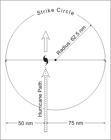
- Strike:
-
 For any particular location, a hurricane
strike occurs if that location passes within the hurricane's strike
circle, a circle of 125 n mi diameter, centered 12.5 n mi to the right
of the hurricane center (looking in the
direction of motion). This circle is meant to depict the typical
extent of hurricane force winds, which are approximately 75 n mi to
the right of the center and 50 n mi to the left.
For any particular location, a hurricane
strike occurs if that location passes within the hurricane's strike
circle, a circle of 125 n mi diameter, centered 12.5 n mi to the right
of the hurricane center (looking in the
direction of motion). This circle is meant to depict the typical
extent of hurricane force winds, which are approximately 75 n mi to
the right of the center and 50 n mi to the left.
- Subtropical Cyclone:
- A non-frontal low pressure system that has characteristics of both
tropical and extratropical cyclones.
The most common type is an upper-level cold low with circulation
extending to the surface layer and maximum sustained winds generally
occurring at a radius of about 100 miles or more from the
center. In
comparison to tropical cyclones,
such systems have a relatively broad
zone of maximum winds that is located farther from the center, and
typically have a less symmetric wind field and distribution of
convection.
A second type of subtropical cyclone is a mesoscale low originating in
or near a frontolyzing zone of horizontal wind shear, with radius of
maximum sustained winds generally less than 30 miles. The entire
circulation may initially have a diameter of less than 100 miles.
These generally short-lived systems may be either cold core or warm
core.
- Subtropical Depression:
- A subtropical cyclone
in which the maximum sustained surface wind
speed (using the U.S. 1-minute average) is 33 kt (38 mph or 62 km/hr)
or less.
- Subtropical Storm:
- A subtropical cyclone
in which the maximum sustained surface wind
speed (using the U.S. 1-minute average) is 34 kt (39 mph or 63 km/hr)
or more.
- Synoptic Track:
- Weather reconnaissance
mission flown to provide vital
meteorological information in data sparse ocean areas as a supplement
to existing surface, radar, and satellite data. Synoptic flights
better define the upper atmosphere and aid in the prediction of
tropical cyclone
development and movement.
- Tropical Cyclone:
- A warm-core non-frontal synoptic-scale cyclone, originating over
tropical or subtropical waters, with organized deep convection and a
closed surface wind circulation about a well-defined
center. Once
formed, a tropical cyclone is maintained by the extraction of heat
energy from the ocean at high temperature and heat export at the low
temperatures of the upper troposphere. In this they differ from
extratropical cyclones,
which derive their energy from horizontal
temperature contrasts in the atmosphere (baroclinic
effects).
- Tropical Cyclone Plan of the Day:
- A coordinated mission plan that tasks operational
weather reconnaissance
requirements during the next 1100 to 1100 UTC day or as
required, describes reconnaissance flights committed to satisfy both
operational and research requirements, and identifies possible
reconnaissance requirements for the succeeding 24-hour
period.
- Tropical Depression:
- A tropical cyclone
in which the maximum sustained surface wind
speed (using the U.S. 1-minute average) is 33 kt (38 mph or 62 km/hr)
or less.
- Tropical Disturbance:
- A discrete tropical weather system of apparently organized
convection -- generally 100 to 300 nmi in diameter -- originating in the
tropics or subtropics, having a nonfrontal migratory character, and
maintaining its identity for 24 hours or more. It may or may not be
associated with a detectable perturbation of the wind
field.
- Tropical Storm:
- A tropical cyclone
in which the maximum sustained surface wind
speed (using the U.S. 1-minute average) ranges from 34 kt (39 mph or
63 km/hr) to 63 kt (73 mph or 118 km/hr).
- Tropical Storm Warning:
- A warning that sustained winds within the range of 34 to 63 kt (39
to 73 mph or 63 to 118 km/hr) associated with a
tropical cyclone are
expected in a specified coastal area within 24 hours or less.
- Tropical Storm Watch:
- An announcement for specific coastal areas that
tropical storm
conditions are possible within 36 hours.
- Tropical Wave:
- A trough or cyclonic curvature maximum in the trade-wind
easterlies. The wave may reach maximum amplitude in the lower middle
troposphere.
|